meinmarokko.com
The Todra Gorge
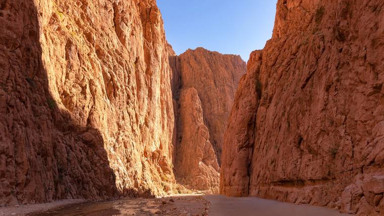
The Todra GorgePhoto: iStock.com/Astalor

South-east · Draa-Tafilalet

Tinghir

also Tinerhir

31° 31′ N · 5° 32′ W

Capital of Tinghir province in the oasis valley of the Todgha on the southern slopes of the High Atlas; north of the town the river has cut a limestone gorge.

Open on the mapopens the map at this spot

Location

Tinghir belongs to Tinghir province in the Draa-Tafilalet region and has been its capital since the province was created in 2009; before that the town was part of Ouarzazate province. In 2024 the municipality had 44,239 inhabitants and the province 323,805.

The town lies between the Central High Atlas to the north, which rises above 4,000 metres in the Mgoun, and the Djebel Saghro to the south. Through this depression runs the road from Ouarzazate via Skoura, Kelaat M’Gouna and the Dadès to the Tafilalet.

The Todgha is an oasis valley on the southern slopes of the High Atlas; it belongs to the Todgha-Ferkla basin. Around the year 2000 some 70,000 people lived here in 64 ighermane, fortified villages of rammed earth, plus about 25,000 in Tinghir itself. The oasis stretches for around 30 kilometres along the river and is between 200 metres and 4 kilometres wide.

Economy

How the land is irrigated depends on its position in the valley. In the upper Todgha, where the Aït Todoght live, the river carries water all year round and is diverted directly; land is scarce there because the valley is narrow. Around Tinghir the flow is not assured throughout the year, so the villages take turns according to a fixed rota. In the lower Todgha, the territory of the Aït Atta, and in the Ferkla, traditional irrigation depends mainly on khettaras, underground channels that the village communities maintained together.

Nature

About fifteen kilometres from Tinghir the Todgha has cut a gorge through limestone, the Gorges du Todgha, also called the Todra. For the height of the walls the sources give figures from 300 metres to 400 metres. Over the last 600 metres the gorge narrows in places to only about ten metres; in the dry season its floor is usually dry, while in the rainy season the river can flood it completely.

The walls are a popular climbing area with well-equipped routes. At the foot of the cliffs there is a via ferrata for beginners and experienced climbers, and young people from the area offer guiding, courses and equipment hire.

In brief

Region
Draa-Tafilalet, Tinghir province
Population
44,239 in the municipality, 323,805 in the province (2024)
Oasis
Todgha, around 2000 some 70,000 inhabitants in 64 ighermane and the town
Gorge
Gorges du Todgha, walls 300 to 400 m

Months with a mild climate

JFMAMJJASOND

February, March, April, October, November. Months with average daily highs between 17 and 30 °C and less than 60 mm of rain; Errachidia (WMO 60210, 1037 m, 1991–2020).

Pass on

Send this place to family and friends or copy the link.

Nearby

As the crow flies, not road distance.

Checked on 24 Oct 2026. Every number in the text opens its source.

  1. Secrétariat général du gouvernement, Bulletin officiel: Décret n° 2-15-40 du 20 février 2015 fixant le nombre des régions, leurs dénominations, leurs chefs-lieux ainsi que les préfectures et provinces qui les composent (BO n° 6340, édition de traduction officielle, 5 mars 2015). http://www.sgg.gov.ma/BO/bo_fr/2015/BO_6340_fr.pdf. Checked on 24 Oct 2026.
  2. Wikipedia (fr): Tinghir. https://fr.wikipedia.org/wiki/Tinghir. Checked on 24 Oct 2026.
  3. Haut-Commissariat au Plan: Population légale du Royaume du Maroc selon les résultats du Recensement Général de la Population et de l'Habitat de 2024 (par région, province, cercle et commune). https://www.hcp.ma/file/242342/. Checked on 24 Oct 2026.
  4. Wikipedia (fr): Tinghir. https://fr.wikipedia.org/wiki/Tinghir. Checked on 24 Oct 2026.
  5. Hein de Haas, Universität Oxford: Gestion d'eau dans les oasis marocaines, migrations et le rôle de l'état: crise ou transformation? L'exemple du Todgha-Ferkla (2007). https://heindehaas.org/wp-content/uploads/2015/05/de-haas-2007-gestion-d-eau-oasis.pdf. Checked on 24 Oct 2026.
  6. Wikipedia (fr): Tinghir. https://fr.wikipedia.org/wiki/Tinghir. Checked on 24 Oct 2026.
  7. Hein de Haas, Universität Oxford: Gestion d'eau dans les oasis marocaines, migrations et le rôle de l'état: crise ou transformation? L'exemple du Todgha-Ferkla (2007). https://heindehaas.org/wp-content/uploads/2015/05/de-haas-2007-gestion-d-eau-oasis.pdf. Checked on 24 Oct 2026.
  8. Libération (Casablanca), über AllAfrica: Maroc: Les gorges de Toudgha, une oeuvre de la nature au coeur du Haut Atlas (26. Januar 2026). https://fr.allafrica.com/stories/202601270165.html. Checked on 24 Oct 2026.
  9. Wikipedia (en): Todgha Gorge. https://en.wikipedia.org/wiki/Todgha_Gorge. Checked on 24 Oct 2026.
  10. Wikipedia (fr): Gorges du Toudra. https://fr.wikipedia.org/wiki/Gorges_du_Toudra. Checked on 24 Oct 2026.
  11. Libération (Casablanca), über AllAfrica: Maroc: Les gorges de Toudgha, une oeuvre de la nature au coeur du Haut Atlas (26. Januar 2026). https://fr.allafrica.com/stories/202601270165.html. Checked on 24 Oct 2026.
  12. Wikipedia (en): Todgha Gorge. https://en.wikipedia.org/wiki/Todgha_Gorge. Checked on 24 Oct 2026.
  13. Wikipedia (fr): Gorges du Toudra. https://fr.wikipedia.org/wiki/Gorges_du_Toudra. Checked on 24 Oct 2026.
  14. Libération (Casablanca), über AllAfrica: Maroc: Les gorges de Toudgha, une oeuvre de la nature au coeur du Haut Atlas (26. Januar 2026). https://fr.allafrica.com/stories/202601270165.html. Checked on 24 Oct 2026.
  15. Secrétariat général du gouvernement, Bulletin officiel: Décret n° 2-15-40 du 20 février 2015 fixant le nombre des régions, leurs dénominations, leurs chefs-lieux ainsi que les préfectures et provinces qui les composent (BO n° 6340, édition de traduction officielle, 5 mars 2015). http://www.sgg.gov.ma/BO/bo_fr/2015/BO_6340_fr.pdf. Checked on 24 Oct 2026.
  16. Haut-Commissariat au Plan: Population légale du Royaume du Maroc selon les résultats du Recensement Général de la Population et de l'Habitat de 2024 (par région, province, cercle et commune). https://www.hcp.ma/file/242342/. Checked on 24 Oct 2026.
  17. Hein de Haas, Universität Oxford: Gestion d'eau dans les oasis marocaines, migrations et le rôle de l'état: crise ou transformation? L'exemple du Todgha-Ferkla (2007). https://heindehaas.org/wp-content/uploads/2015/05/de-haas-2007-gestion-d-eau-oasis.pdf. Checked on 24 Oct 2026.
  18. Wikipedia (fr): Gorges du Toudra. https://fr.wikipedia.org/wiki/Gorges_du_Toudra. Checked on 24 Oct 2026.
    Libération (Casablanca), über AllAfrica: Maroc: Les gorges de Toudgha, une oeuvre de la nature au coeur du Haut Atlas (26. Januar 2026). https://fr.allafrica.com/stories/202601270165.html. Checked on 24 Oct 2026.
  19. NOAA National Centers for Environmental Information (NCEI): WMO Climatological Standard Normals 1991–2020, Station Errachidia (WMO 60210). https://www.ncei.noaa.gov/data/oceans/archive/arc0216/0253808/6.6/data/0-data/Region-1-WMO-Normals-9120/Morocco/CSV/ERRACHIDIA_60210.csv. Checked on 24 Oct 2026.