All places
85 places in Morocco from the Rif to Dakhla, each with its own story, location and surroundings.
Search on the mapthe same places, on the map
From north to south
 NorthTangierA port city at the entrance to the Strait of Gibraltar, on a bay between Cap Spartel and Cap Malabata. With 1,275,428 inhabitants, Tangier is Morocco's second-largest city after Casablanca (2024).NorthM’diqA coastal town 13 kilometres from Tetouan, whose port was built from 1961 and has taken pleasure boats since 1966; a new marina was added in 2009. In 2024 M’diq had 67,599 inhabitants.NorthMartilA coastal town in the Martil plain, one of the narrow coastal plains at the river mouths near Tetouan, and the largest municipality in the prefecture of M’diq-Fnideq: it grew from 64,355 inhabitants in 2014 to 95,896 in 2024, an average of 4.07 per cent a year.NorthTetouanRefounded in the 15th century by families from Andalusia, with a medina that has been a World Heritage site since 1997. UNESCO calls it one of the smallest medinas in Morocco and at the same time the most complete.NorthAsilahAn Atlantic town 40 kilometres south of Tangier whose medina is enclosed by walls dating from the time of the Portuguese trading post. Since 1978 the Fondation du Forum d’Assilah has held its cultural moussem here; in 2024 the municipality had 36,039 inhabitants.EastBeni AnsarBeni Ansar lies on the north-western side of the Marchica lagoon and is home to the port of Nador. The railway line from Taourirt ends at Beni Ansar Port station. In 2024 the town had 50,508 inhabitants.NorthAl HoceimaA port town at the western end of the bay of Al Hoceima, with the Rif at its back. Near the town lies the only national park on Morocco's Mediterranean coast that also includes a marine area.NorthLaracheA port town on the left bank of the Oued Loukkos, about 750 metres from its mouth; in 2024 it had 133,731 inhabitants. Opposite lies the ancient city of Lixus, inhabited from the 8th century BC until the 14th century and on the World Heritage Tentative List since 1995.
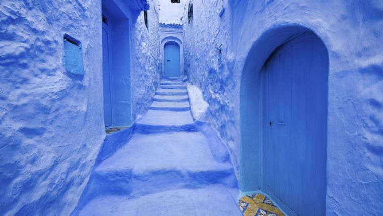 NorthChefchaouenA mountain town in the western Rif, founded in 1471, a town of Andalusian tradition. In 2010 it represented Morocco in the UNESCO nomination for the Mediterranean diet.EastNadorNador lies on the Marchica lagoon, which has been listed as a wetland of international importance since 2005. With 158,202 inhabitants (2024) it is the second-largest city in the Oriental region.NorthImzourenAfter Al Hoceima the largest municipality in the province of Al Hoceima, with 34,848 inhabitants in 2024, on the Ghis-Nekor plain, whose groundwater supplies a large share of the area’s drinking water.EastRas el MaRas El Ma, also called Ras Kebdana, lies at the mouth of the Moulouya and had 7,527 inhabitants in 2024. The estuary has been a Ramsar site since 2005.EastKariat ArekmaneKariat Arekmane lies on the south-eastern side of the Marchica lagoon. The urban centre had 4,602 inhabitants in 2024, the municipality of Arekmane as a whole 16,477.EastSaïdiaSaïdia, bounded to the west by the Moulouya, belongs to Berkane province and had 10,514 inhabitants in 2024. On 19 June 2009 Mediterrania Saïdia, the first resort of the Plan Azur, opened here.EastSelouaneBetween 2014 and 2024 Selouane grew by 8,058 to 29,628 inhabitants, at 3.2 per cent a year faster than any other town in the region. Since September 2005 the Faculté Pluridisciplinaire de Nador of the Université Mohammed Premier has been teaching here.NorthKsar el-KebirA town on the Loukkos and the main market of the irrigated Loukkos valley. After Larache it is the second-largest municipality in Larache province: in 2024 Ksar el-Kebir had 124,701 inhabitants, compared with 126,617 in 2014.EastAl ArouiAl Aroui is an urban municipality in Nador province and had 46,540 inhabitants in 2024. In 2023 Nador-El Aroui airport passed the mark of one million passengers a year for the first time.EastDriouchDriouch is the capital of Driouch province in the Rif, created in 2009. In the province 89.6 per cent of the people speak Tarifit.EastAhfirAhfir lies on the left bank of the Oued Kiss at the foot of the Beni Snassen, between the plains of Triffa and Angad. The town in Berkane province had 16,310 inhabitants in 2024.EastZaioZaïo lies roughly halfway between Nador and Berkane on the Sebra plain. The town in Nador province had 36,766 inhabitants in 2024; in the same year its sugar factory processed 115,900 tonnes of sugar beet.NorthTarguistA small town in a basin of the Rif in the province of Al Hoceima, which had 14,638 inhabitants in 2024, compared with 13,390 in 2014. Unlike nearby Imzouren, just over half of the people here spoke only Darija in everyday life in 2014.EastMidarMidar is one of the three urban municipalities of the province of Driouch, created in 2009, and lies near the middle course of the Oued Kert on the eastern edge of the Rif. In 2024 the town had 15,391 inhabitants.EastBerkaneBerkane lies on the Triffa plain at the foot of the Beni Snassen. Since 2010 the plain's clementines have carried the protected indication “Clémentine de Berkane”.NorthOuezzaneA town between the foothills of the Rif and the Gharb plain that grew up in the early 17th century around the zawiya of Moulay Abdallah Chérif. In 2024, 57,737 of the 274,577 inhabitants of Ouezzane province lived here.EastOujdaOujda is the seat of the Oriental region and, with 506,224 inhabitants (2024), its largest city. It was founded in 994.EastTaourirtTaourirt had 100,402 inhabitants in 2024; only Oujda and Nador are larger in the Oriental. Its fortress was built in 1295 on the orders of the Marinid sultan Abu Yaqub Yusuf, on what was then the border of his realm.EastJeradaJerada grew up around an anthracite deposit that was mined from 1930 onwards. The town is the capital of the province of the same name and had 41,014 inhabitants in 2024.AtlanticKenitraA city on the Sebou, 14 kilometres north-east of the Sidi Boughaba Ramsar site and terminus of the high-speed line from Tangier.EastGuercifGuercif is the seat of a province created by decree in 2009 and part of the Oriental region since 2015. The town had 80,703 inhabitants in 2024; olive growing is the province’s main branch of farming.Imperial citiesTazaTaza lies in a narrow pass between the Rif and the Middle Atlas that links eastern and western Morocco. The city's Almohad Great Mosque has been on UNESCO's Tentative List since 1995.Imperial citiesMoulay IdrissMoulay Idriss Zerhoun borders the archaeological site of Volubilis and holds the tomb of Idris I, founder of the Idrisid dynasty. The municipality had 10,038 inhabitants in 2024, and the town has been on UNESCO’s Tentative List since 1995.AtlanticSaléRabat's neighbouring city on the right bank of the Bou Regreg, with a Great Mosque of 1196 and a Marinid madrasa.
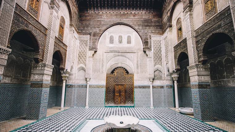 Imperial citiesFezFez is the capital of the Fez-Meknes region. Its medina has been on the World Heritage List since 1981 and, in UNESCO's assessment, is one of the most extensive and best-preserved historic towns of the Arab-Muslim world.
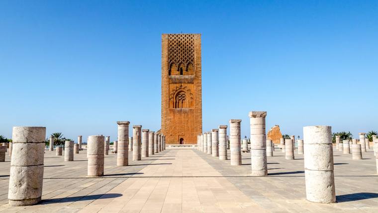 AtlanticRabatCapital of the Kingdom and a World Heritage site since 2012: a new town dating from 1912 onwards and an old town whose buildings go back to the 12th century.AtlanticTémaraThe municipality of Temara in the prefecture of Skhirate-Temara had 297,098 inhabitants in 2024. In the Grotte des Contrebandiers, a cave on the Atlantic coast within the town limits, archaeologists found bone tools between 120,000 and 90,000 years old.Imperial citiesMeknesUnder Sultan Moulay Ismail (1672–1727) Meknes became the capital and was given a royal city with walls up to 15 metres high and monumental gates; the historic city has been a World Heritage site since 1996.Imperial citiesSefrouThe municipality of Sefrou had 86,903 inhabitants in 2024 and gives its name to a province of the Fez-Meknes region. Its three-day cherry festival in June, with a Cherry Queen and a parade, has been on UNESCO’s list of intangible cultural heritage since 2012.AtlanticMohammediaMohammedia, formerly Fédala, grew from 1912 around a port that specialised in oil from the mid-1920s. In 2024 the municipality had 194,358 inhabitants and the prefecture of the same name 514,057.
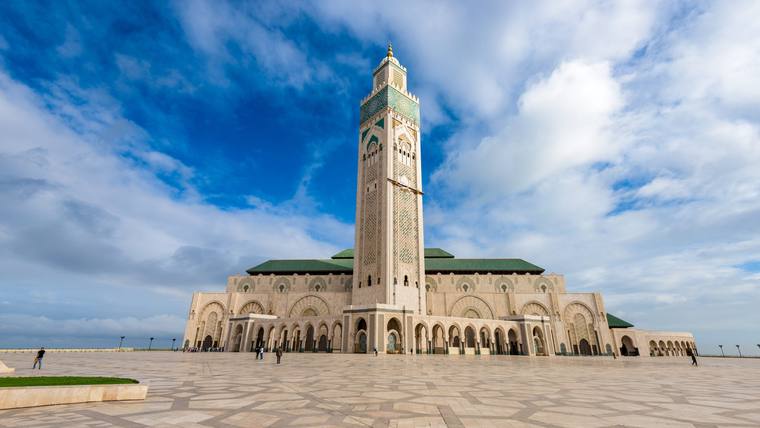 AtlanticCasablancaThe economic capital of the Kingdom and, with around 3.2 million inhabitants, the largest city in the country. Its landmark is the Hassan II Mosque with a 200-metre minaret.Imperial citiesIfraneIfrane was founded in 1929 in the Middle Atlas at around 1,650 metres and is home to the English-language Al Akhawayn University. The weather station records an average of 961 millimetres of precipitation a year.Imperial citiesAzrouWith 57,657 inhabitants (2024), Azrou is the largest municipality in Ifrane province. The old Amazigh settlement lies at about 1,204 metres, 17 kilometres south-west of Ifrane.AtlanticBerrechidBerrechid province lies in the plains of the Chaouia and was split off from Settat province in 2009. The municipality of Berrechid had 168,687 inhabitants in 2024. This is where the A4 motorway to Beni Mellal begins; its first section, to Ben Ahmed, has been open since 1 July 2015.AtlanticEl JadidaThe Portuguese fortified town of Mazagan, begun in 1514 and expanded into a star-shaped fortress in 1541–1548, has been on the World Heritage List since 2004; in the mid-19th century it was restored and named El Jadida. The municipality had 237,464 inhabitants in 2024.Imperial citiesMissourMissour is the seat of Boulemane province in the Fez-Meknes region and had 28,408 inhabitants in 2024. The town lies on the Moulouya; the high plateaus of Missour serve mainly as grazing land for sheep and goats.AtlanticSettatSettat is the largest market town of the fertile Chaouia plain; its best-known building is a kasbah that Sultan Moulay Ismail had built in the late 17th century. The municipality had 171,556 inhabitants in 2024, and the Université Hassan I was founded here in 1997.Middle AtlasKhenifraKhenifra lies on the Oum Er-Rbia in the western foothills of the Middle Atlas; in 1688 Sultan Moulay Ismail had a kasbah and a bridge built here. The municipality had 123,738 inhabitants in 2024.Middle AtlasKhouribgaKhouribga lies on the phosphate plateau west of the Middle Atlas and owes its growth to the phosphate deposits that have been mined since 1921. The municipality had 195,931 inhabitants in 2024. Since 2014 a 187-kilometre pipeline has carried the phosphate as slurry to the Jorf Lasfar industrial platform.AtlanticOualidiaOualidia lies at the southern end of the Sidi Moussa-Walidia wetland complex with its two lagoons, which has been on the Ramsar List since 2005. The municipality of Loualidia in Sidi Bennour province had 21,742 inhabitants in 2024.South-eastMideltCapital of Midelt province on the high plateau between the Middle and High Atlas; the municipality had 62,648 inhabitants in 2024. Since 2013 the apples of the area have carried a protected geographical indication.EastBouarfaBouarfa is the seat of Figuig province and, with 30,068 inhabitants (2024), its largest municipality. Near the town lies a manganese and iron deposit from which more than 1.5 million tonnes of manganese have been extracted.Middle AtlasBeni MellalA city at the foot of the Middle and High Atlas, lying between 480 and 620 metres, overlooked by the 2,240-metre Tassemit.CentreSafiSafi is a port city on the Atlantic with buildings from the Almohad and Portuguese periods; for its pottery UNESCO admitted it in 2025 as a Creative City of Crafts and Folk Art.CentreYoussoufiaYoussoufia lies in the province of the same name in the Marrakesh-Safi region and had 65,669 inhabitants in 2024. The town grew up from 1931 on the Gantour phosphate deposit and was called Louis-Gentil until after independence.EastFiguigThe oasis of Figuig, with its seven ksour, the terraced gardens of its palm grove and its irrigation system, has been on UNESCO’s World Heritage Tentative List since 2011. Since 2022 the FAO has listed the ksour of Figuig as a Globally Important Agricultural Heritage System (GIAHS).South-eastErrachidiaCapital of the Draa-Tafilalet region on the Oued Ziz, with 97,687 inhabitants (2024). The reservoir of the Hassan Addakhil dam is part of the Oasis du Tafilalet Ramsar site.
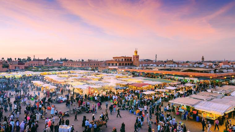 CentreMarrakeshThe Almoravids founded Marrakesh in 1070–1072, its medina has been on the World Heritage List since 1985, and Jemaa el-Fna square is part of the Intangible Cultural Heritage of Humanity.CentreChichaouaChichaoua lies in the province of the same name in the Marrakesh-Safi region and had 38,452 inhabitants in 2024. In the 16th century the Saadians built sugar mills in the area; the remains of the southern mill have been a protected monument since 2022.
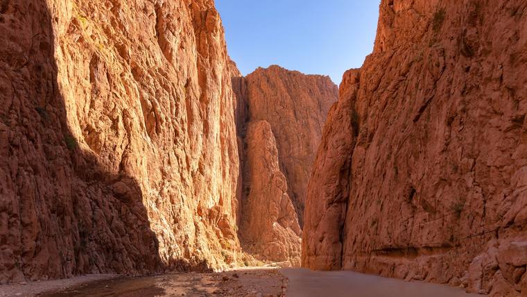 South-eastTinghirCapital of Tinghir province in the oasis valley of the Todgha on the southern slopes of the High Atlas; north of the town the river has cut a limestone gorge.CentreEssaouiraEssaouira was laid out in the mid-18th century as a fortified port city on a European model; its medina has been a World Heritage site since 2001.South-eastErfoudErfoud, listed as Arfoud in the official statistics, is a municipality in Errachidia province with 28,912 inhabitants (2024). It hosts the international date fair SIDATTES, and a fossil-rich limestone traded as “Marbre d'Erfoud” is quarried and worked here.South-eastBoumalne DadèsBoumalne Dadès is an urban municipality in Tinghir province in the Draa-Tafilalet region and had 12,391 inhabitants in 2024. Between Boumalne and M'semrir the Dadès has cut a gorge about five kilometres long and more than 200 metres deep into Lower Jurassic limestone.South-eastRissaniRissani grew out of the ksour of the oasis of Sijilmassa, the caravan city founded on the Ziz in the 8th century that is regarded as the cradle of the Alaouites.CentreAsniAsni is a rural municipality of Al Haouz province at the foot of the High Atlas, on the edge of Toubkal National Park; in 2024 it had 22,637 inhabitants. A weekly market is held here on Saturdays.South-eastKelaat M’GounaA town in Tinghir province with 17,737 inhabitants (2024). It gives its name to the protected designation of origin “Rose de Kelâat M’Gouna-Dadès”, in force since 2011, and every May it hosts the Salon international de la rose à parfum.CentreImlilImlil, a village in Al Haouz province, is a favoured starting point for climbing Toubkal, the highest peak in North Africa. The area's mountain guides' association has its office here.South-eastMerzougaA village at the foot of Erg Chebbi, whose highest dune rises more than 200 metres above the plain; next to it lies the rain-fed lake Dayet Srij.South-eastSkouraAn oasis in Ouarzazate province, watered by three rivers from the High Atlas and by underground khettaras; the municipality of Skoura Ahl El Oust had 24,053 inhabitants in 2024, 4,576 of them in the urban centre of Skoura.
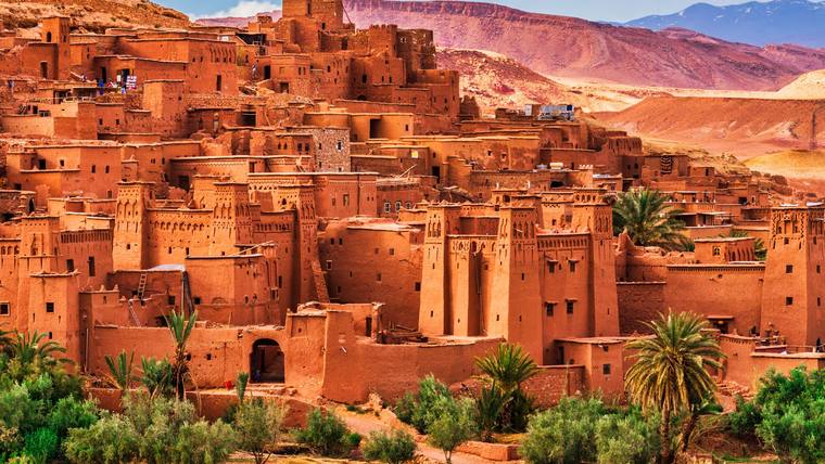 South-eastAït Ben HaddouThe ksar of Aït-Ben-Haddou in the Ounila valley of Ouarzazate province has been a World Heritage site since 1987: earthen houses behind high walls with corner towers, the oldest probably from the 17th century.South-eastOuarzazateCapital of Ouarzazate province, where the Dadès and the Imini meet to form the Drâa; the same province is home to the ksar of Aït-Ben-Haddou, a World Heritage site since 1987.SouthTaghazoutTaghazout is a municipality in the prefecture of Agadir-Ida-Ou-Tanane and had 4,861 inhabitants in 2024. The village has a centre for small-scale fishing; next to it lies the Taghazout Bay resort with a 27-hole golf course, whose operating company was founded in 2011.SouthTaroudantA town in the Souss valley enclosed by a wall with nine gates, several times the administrative seat of the region in the course of its history.
 SouthAgadirA port city on an Atlantic bay north of the Oued Souss, rebuilt after the earthquake of 1960.South-eastZagoraCapital of Zagora province in the Drâa valley; on Jbel Zagora, opposite the town, lie the remains of an 11th-century Almoravid fortress.SouthTafraouteTafraoute lies in a mountain oasis in the western Anti-Atlas, adjoined to the north and west by the green Ameln valley. The municipality, in Tiznit province, had 6,124 inhabitants in 2024.SouthTiznitA town of silversmiths behind a wall about six kilometres long, founded in 1882 by Sultan Hassan I.SouthMirleftMirleft is a municipality in Sidi Ifni province in the Guelmim-Oued Noun region, with six beaches along its coast. Its population rose from 8,162 in 2014 to 9,828 in 2024.South-westSidi IfniSidi Ifni lies on the Atlantic coast about 170 kilometres south of Agadir; its port serves mainly the fishing industry. In 2024 the town had 22,696 inhabitants.South-westGuelmimGuelmim is the capital of the Guelmim-Oued Noun region and, with 126,729 inhabitants (2024), its largest municipality. Its weekly Amhayrich market includes a livestock trading area.South-westTan-TanTan-Tan had 76,134 inhabitants in 2024, and its fishing and trading port lies 25 kilometres south of the town. The Moussem of Tan-Tan, an annual gathering of more than thirty tribes, was first held in 1963 and has been on UNESCO's list of intangible cultural heritage since 2008.SaharaTarfayaTarfaya had 11,030 inhabitants in 2024. From October 1927 to the end of 1928 Antoine de Saint-Exupéry ran the airfield here, then called Cap Juby, on the airmail route from Casablanca to Dakar; since 2004 a museum of the Aéropostale has commemorated him.SaharaLaayouneThe largest city in the Laayoune-Sakia El Hamra region, with the most important port in the south.SaharaSmaraSmara, the capital of Es-Semara province, had 56,607 inhabitants in 2024. The town grew up around a zawiya founded by Sheikh Maâ El Aïnin in 1898.SaharaBoujdourBoujdour had 57,360 inhabitants in 2024. Besides a shelter port for small-scale fishing, the town has had a new port since 26 April 2012, mainly for coastal fishing.SaharaDakhlaA city on a 45-kilometre peninsula off the bay of Dakhla, a wetland of international importance.
By region
NorthTangier-Tetouan-Al Hoceima · 13 places
Fnideq · Tangier · M’diq · Martil · Tetouan · Asilah · Al Hoceima · Larache · Chefchaouen · Imzouren · Ksar el-Kebir · Targuist · Ouezzane
EastOriental · 18 places
Beni Ansar · Nador · Ras el Ma · Kariat Arekmane · Saïdia · Selouane · Al Aroui · Driouch · Ahfir · Zaio · Midar · Berkane · Oujda · Taourirt · Jerada · Guercif · Bouarfa · Figuig
Imperial citiesFez-Meknes · 8 places
Taza · Moulay Idriss · Fez · Meknes · Sefrou · Ifrane · Azrou · Missour
AtlanticRabat-Sale-Kenitra · 4 places
AtlanticCasablanca-Settat · 6 places
Mohammedia · Casablanca · Berrechid · El Jadida · Settat · Oualidia
Middle AtlasBeni Mellal-Khenifra · 3 places
CentreMarrakesh-Safi · 7 places
Safi · Youssoufia · Marrakesh · Chichaoua · Essaouira · Asni · Imlil
South-eastDraa-Tafilalet · 12 places
Midelt · Errachidia · Tinghir · Erfoud · Boumalne Dadès · Rissani · Kelaat M’Gouna · Merzouga · Skoura · Aït Ben Haddou · Ouarzazate · Zagora
SouthSouss-Massa · 6 places
Taghazout · Taroudant · Agadir · Tafraoute · Tiznit · Mirleft