South-east · Draa-Tafilalet
Aït Ben Haddou
also Ait Benhaddou
31° 03′ N · 7° 08′ W
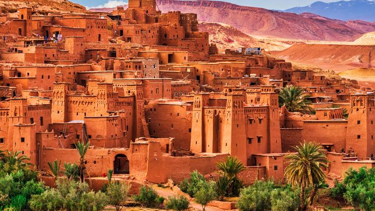
The ksar of Aït-Ben-Haddou in the Ounila valley of Ouarzazate province has been a World Heritage site since 1987: earthen houses behind high walls with corner towers, the oldest probably from the 17th century.
Open on the mapopens the map at this spot
Location
Aït-Ben-Haddou lies in Ouarzazate province, part of the Draa-Tafilalet region. It stands in the foothills on the southern slopes of the High Atlas, and UNESCO calls it the best-known ksar of the Ounila valley. It is built entirely of earth on rugged, raised ground some 30 kilometres north-west of Ouarzazate; the 1987 ICOMOS evaluation gives the distance as 31 kilometres. The ksar belongs to the rural municipality of Aït Zineb, which had 10,530 inhabitants at the 2024 census.
Unlike the kasbah of a single family, a ksar (plural ksour) is a mainly communal settlement: behind defensive walls with corner towers stand houses, stables, granaries, a market, a meeting room for the jemaa, the council of family heads, and a mosque. The large houses are called tighremt in Tamazight and dar or kasba in Arabic; four wings with tall corner towers enclose a rectangular courtyard. At Aït-Ben-Haddou some houses are modest, while others resemble small castles whose upper sections are decorated with patterns in mud brick; a bent entrance leads through the wall.
History
Written records of the place go back only to the 18th century, oral tradition further. The oldest structure is said to be the granary at the highest point, in Tamazight Ighrem n Iqddarn, the potters’ granary. UNESCO dates the oldest surviving buildings no earlier than the 17th century, although the building methods and techniques in the valleys of southern Morocco are much older. The village was one of the stops on the trade route linking ancient Sudan with Marrakesh by way of the Draa valley and the Tizi-n’Telouet pass. The director of the Moroccan heritage centre CERKAS names Gao, Timbuktu and Djenné as its southern destinations.
According to tradition, Amghar Benhaddou, the first lord of the place, lived here in Almoravid times in the 11th century, and the ksar bears his name. The Alaouite sultan Hassan I passed through Aït-Ben-Haddou in 1893–1894 on his last military expedition, travelling via Telouet to Marrakesh. The Glaoua family then tied itself to the village through marriage: El-Madani, Thami and Hassi Glaoui married three daughters of the ksar’s leading family. Most of the inhabitants belong to two lineages of the Aït Zineb, a tribe of the Aït Ouawzguit confederation; in the past the population was made up mainly of Amazigh families, Haratin and Jewish families. Every year, on the second Saturday of June by the farming calendar, they celebrate the moussem of the local saint Sidi Ali ou Amer.
Landmarks
Above the tightly packed village rises a rounded hill crowned at 1,300 metres by a large communal granary with its own enclosure wall; the large houses stand in a ring at the foot of this hill, built around inner courtyards in rammed earth and mud brick. Fortified granaries, called agadir or ighrem, are common in Morocco, but rarely is their defensive purpose so clear: a fortification links the granary with the village and was meant as a last refuge in the event of a siege. The ksar also has a mosque, a square, threshing floors outside the wall, a caravanserai, a Muslim and a Jewish cemetery, and the shrine of Sidi Ali ou Amer.
UNESCO inscribed the ksar on the World Heritage List in 1987 under criteria iv and v; the property covers 3.03 hectares, the buffer zone 16.32 hectares. ICOMOS saw in it a complete panorama of pre-Saharan earthen building techniques and proposed making it a testing ground for conservation based on traditional techniques of working earth and wood; according to ICOMOS, the village and the valleys of the oasis had already been protected since 1953. The legal basis is mainly heritage law 22-80; the ksar is managed by CERKAS, the centre for the conservation of the architectural heritage of the Atlas and sub-Atlas areas. Since 2000 Aït-Ben-Haddou has been part of the Oasis du sud marocain biosphere reserve, which covers almost 7.2 million hectares.
Today
In the 1960s most residents moved out of the old ksar to a new village on the right bank of the Oued el-Maleh; by 2008 only six families still lived in the ksar. A first management plan covered 2007–2012, followed in November 2020 by the plan for 2020–2030 with five objectives: conservation, revitalisation, cultural activities, communication and training. Since 2011 a footbridge, built at the narrowest point of the riverbed, has crossed the Oued el-Maleh to make it easier to reach the old ksar. After the 2014 floods, lanes and several houses were restored, and in September 2016 a programme to restore the houses began, its first phase costing two million dirhams.
The epicentre of the earthquake of 8 September 2023 lay about 110 kilometres away. According to the CERKAS survey, the houses restored with traditional techniques generally withstood the tremors well. The potters’ granary, the only evidence of a communal granary, collapsed together with three of the five towers of its wall; seven buildings were mainly affected, among them the Aït Ougram and N’Oumghar kasbahs. CERKAS had already restored the granary in 2008; plans include restoring it again and excavating for the remains of earlier granaries. Fewer people now live permanently in the ksar, while shops and guesthouses are increasing.
Economy
The 1987 evaluation already notes that the ksar had become famous among travellers after two major feature films. After the World Heritage inscription, more visitors came, and more film companies too; productions shot here include Lawrence of Arabia, Jesus of Nazareth and Gladiator. Tourism is now the main activity in the village, with shops in both parts of the settlement as well as hotels, inns and cafés.
Climate
The Ouarzazate weather station lies at 1,136 metres. Over the years 1991 to 2020 it recorded an average of 115 millimetres of precipitation a year; the mean daily maximum temperature ranged from 17.3 °C in January to 38.8 °C in July.
In brief
- Region
- Draa-Tafilalet, Ouarzazate province
- Municipality
- Aït Zineb, population 10,530 (2024)
- World Heritage
- since 1987, criteria iv and v, 3.03 ha, buffer zone 16.32 ha
- Elevation
- communal granary on the hilltop, 1,300 m
- Biosphere reserve
- Oasis du sud marocain, since 2000
Months with a mild climate
January, February, March, April, October, November, December. Months with average daily highs between 17 and 30 °C and less than 60 mm of rain; Ouarzazate (WMO 60265, 1136 m, 1991–2020).
Pass on
Send this place to family and friends or copy the link.
Nearby
- Ouarzazate22 km · South-east
- Skoura55 km · South-east
- Imlil76 km · Centre
- Asni84 km · Centre
- Kelaat M’Gouna97 km · South-east
- Marrakesh104 km · Centre
- Boumalne Dadès114 km · South-east
- Zagora147 km · South-east
As the crow flies, not road distance.
Checked on 24 Oct 2026. Every number in the text opens its source.